Saturday, 29 August 2015

Texas and The South (pt. 1)


I made my triumphant return to El Paso on Friday. Not much of a destination, but I did spend a semester at UTEP about 5 years ago and haven't been back since. It was great being back and meeting up with people I hadn't seen in ages.

Things got a little.. fuzzy

Grilling up some burgers on my birthday

Old friends + suspiciously cat-like dog!

I also got to ride the cable tram up to Mount Franklin, an El Paso attraction I hadn't gotten around to during my first stay. Other than that -- so much delicious Mexican food.

Cable tram

After El Paso I begun my trek across West Texas - 8 hours of desolate interstate before getting to Texas Hill country. I am still humbled by the sheer size of this country.

On a related note, Texas has some insane speed limits. I get the 80 - 85mph (130 - 135kph) on the interstates, but back highways and even winding country roads had limits up to 75mph (120kph). Sure, it's fun for a while until someone starts tailgating you for not keeping up.

"Shouldn't we build this bridge a little higher than 2 foot? -nah just put a flood gauge on it, all good."

Coming up on Austin, I got some delicious Texas BBQ a few miles out of town. Not one for lining up, I avoided the well-known spots (Salt Lick, Franklin -- sorry Juliana) and tried a small-town spot. I got to talking with Chris, a power plant engineer who rode the same bike I did.

Old 300 BBQ - delicious!

A refreshing dip in Barton Springs

Austin seemed every bit as great as it's cracked up to be. Unfortunate I didn't get to stay more than a day, but it certainly has a very fun and dynamic vibe.

Heading North from Austin I did have a few run-ins with wildlife. At some point a massive vulture flew past right ahead of the bike -- I ducked instinctively, but it was still a close call. Later, at a north- Texas campsite I got overrun with ants. I spent two hours in the morning cleaning all my bags - they were everywhere! Later, in Arkansas, raccoons stole food from my saddlebags.

Nice sunset though.

As for the South (so far - Oklahoma and Arkansas):

* Some of the most impoverished towns I've seen so far - other than maybe some of the Native reserves.
People really, really have thick dialects. Some fellow pronounced "helmet" as "hammock".
* Confederate flags and "rolling coal" everywhere.
* These folks really, really know their BBQ.
* Beautiful houses! Starting in North-Texas, I've seen some of the most ornate and just beautiful mansions in all of the States.

And a red-brick train station! Very European.


Wednesday, 19 August 2015

The Southwest.

Joshua Tree park was gorgeous. This expanse covers two distinct types of deserts, each with their own vegetation and wildlife. Best known of course is the titular tree. Also in the park was a prospector's old homestead, separated by a mile-long hike from the main road.

I had to go check it out.

The park's exit does leave you stranded in the middle of nowhere though. I took Interstate 10 east to leave California behind. This interstate does go through some low-elevation desert. Temperatures did go up to 43-45 celcius during my trek. Worse, they did not fall below body temperature until well after midnight making my stay in Blythe, CA highly uncomfortable.

Next day I hurried to Arizona around sunrise. By heading northeast to the mountains and their higher elevation I was hoping to avoid another day of 40+ degree weather. I was rewarded by lush forest landscapes alternating more traditional desert vegetation.


I spent the afternoon in Jerome, AZ. This old copper mining town is located on the side of a mountain cliff around a single winding road. It is also the centre of the up and coming Arizona wine scene, with one of the main wineries being owned by James Keenan of Puscifer and Tool fame. Speaking to some of the locals it sounds as though he has made quite the name for himself in the wine industry as well.

I had to indulge in a tasting.

I also spoke to the owner of a hot sauce shop located in town. She moved from Boston in search of a better climate. She kept me from leaving with plenty of samples and tortilla chips.

No samples here though.

I spent the night in Cottonwood, another Old West town. I met an old Vietnam vet who retired here from Alaska. At night I had to find my way back to my camp site by the river in absolute darkness as I was staying in a nature preserve. Good thing I brought my bright flash light.

I woke up to these helpful fellows clearing the ants.

Next few days I spent exploring the Grand Canyon, Zion national park, Vermillion Cliffs, Lake Powell and Horseshoe bend. I won't waste too many words - every single one of these parks is beyond all description, and must be seen, over multiple days, to be believed and experienced.


On the fourth day I headed east towards New Mexico, crossing the vast Najavo reserve. The highlight of the crossing was Najavo Valley. Natives settled in this valley building "pueblos" in the cliff's alcoves.


Exiting the Najavo reserve brought me to New Mexico. Some interesting tidbits;

* Restaurants will almost invariable ask "red or green?", referring to what chili sauce you'd like on your burger, eggs, burrito, ..,
* NM loves its turquoise and pueblo-style buildings - we're talking houses, gas stations, even Walmarts.

Along the way I did contract what I believe to be altitude sickness - a week of ascending and descending thousands of feet per day did take its toll. I am now resting up in Albuquerque for a few days. Not all bad, as I brought the bike in for a major engine service at one of the most highly recommended Triumph dealerships in the southwest.

After all, you want to keep your Triumph running strong in the land of Harley.

Wednesday, 12 August 2015

California - part 2


San Francisco was great. My friend was between house mates so I was free to stay in one of the open bed rooms in the house. Quite the gift in downtown SF, where rooms go for $1,400 to $1,800+ and 1 bedrooms net $3,500 per month. The least I could do was prepare dinner daily and ensure the fridge remained stocked.

Old buddies in one of San Francisco's watering holes.

I was also happy to see traffic in San Francisco, and beyond all the way down to LA. Allow me to elaborate: California I the only North American jurisdiction where "lane filtering", or riding your motorcycle between cars, is allowed. It was beautiful cruising through Napa Valley or random highway backups without much issues. I also can't imagine how I would have gotten through the LA metro area without filtering.

After a few days I headed south on gorgeous highway 1 -- down to Monterrey, the Big Sur, and SoCal.


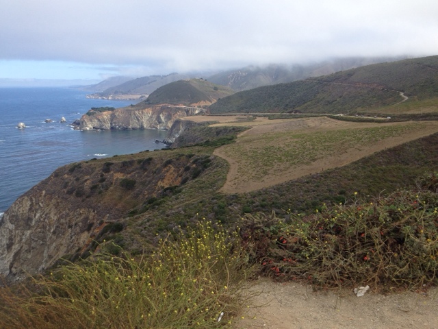
Along the coastal highway I saw magnificent cliffs, beautiful surfer towns, endless white beaches, tourist piers and much, much more.

Massive elephant seals!

Once south of Santa Monica, the towns started exhibiting beautiful "Mission" style architecture. 

Santa Barbara mission.

Gorgeous Ojai, CA.

Who buys ice cream with a check?

I am typing this post from a laundromat in Palm Springs, CA, about an hour into the vast southwestern desert. From here I will be venturing to Joshua Tree, into Arizona,  over to Utah and from there New Mexico and El Paso. Better keep my water jugs full.

Monday, 3 August 2015

California - part 1


I entered California through scenic highway 199 which led directly into the Redwoods and famous coastal highway 101. Quite the drive -- despite the thick haze over the Pacific.


I stayed at a campsite a few miles inland -- where it was noticeably warmer. No cell reception, but I had an interesting chat with Mike, who had been coming to the campsite for over 15 years and was 8 months from retirement, and his son Mike (!), a Gamestop store manager.

I got up early to take the Scenic bypass which led straight into the heart of the Redwoods. Massive Sequoias flanked the highway.


Jacket for scale.

The call is coming from inside the tree!

Around lunchtime I would head further inland. I found a nice 200 mile loop through the coastal range. Little did I know this would completely change my course through Cali.

 Beautiful scenery, but what smokey skies...

After completing the first leg of the loop I found the other highway closed off. Turns out -- there's quite a few forest fires going on. I was to stay inland. The next few days more and more highways across the coastal range would be closed off, and as of today only 2 highways across the mountains are open between Oregon and SF (350 miles).

No problem though. This would give me a chance to explore the Sierras - starting with Lassen Volcanic Park. A winding highway goes up to 8600ft (with an additional hike up to 10k ft).

I made it a 100 yards in.

Lassen Peak.


Coming down from the Sierras I took historic highway 70, which followed the course of the Feather River. Gorgeous scenery, the highway runs across from a railroad, which cross each other several times and run over several dams. Some very impressive engineering work on display here.

Breakfast at the Sacramento River

Also, for some reason tent camping in California is.. Different. About half of the camp sites I tried did not offer tent camping. At. All. One host had no idea what I was asking. Others seemed genuinely surprised I asked. Camping with a tent -- what a novel idea.
A far cry from the beautiful $15 camp sites in Wyoming or free downtown camping in South Dakota's state Capitol.

$6.81 Burrito lunch! Delicious California-Mexican.

Today I finally headed made it down to San Francisco. Heading over the Richmond bay bridge and, of course, the Golden Gate by motorcycle were truly humbling experiences and might very well be the reason I took this trip.

I'll be meeting several friends in the city - one of which graciously offered to host me for a few days.